Presented By: Partner Insights
Nearmap Makes Appraisals a Work-From-Home Task
By Partner Insights June 9, 2020 12:18 pm
reprints
As we wrestle with the evolving ramifications of the COVID-19 pandemic, the commercial real estate world is learning how to conduct business at a distance, leaving previously on-site activities on the sidelines.
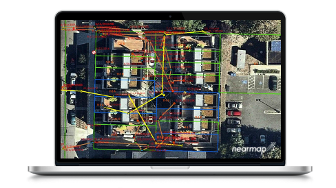
Using the highest-resolution aerial imagery, Nearmap helps design and construction firms, developers, and potential buyers closely inspect properties remotely, as they demonstrated in a recent webinar hosted by the Commercial Observer Partner Insights team.
Moderated by the company’s content marketing manager, Angela Brewster, the webinar featured on-the-ground insights from Nearmap account executive Cody Kessler, who specializes in consulting with architecture, engineering, and construction firms on how to use high-resolution 2D and 3D location content to help enhance and streamline their planning and design workflows.
The Sydney, Australia-based Nearmap flies regularly across the U.S., Canada, Australia and New Zealand, Brewster said. Kessler walked webinar participants through detailed insights on how Nearmap’s graphic representations of sites and properties save companies time and money as compared to on-site visits, and helps them stay competitive in our new remote world.
“Nearmap is a geospatial intelligence company that has been serving location content to government and business since 2007, and we pioneered the world’s first end-to-end processing pipeline,” said Kessler. “What that means is that we own the camera system, we fly the planes, we own the software that stitches the content together, and ultimately we own the software that presents it to you in a cloud-based fashion.”
Before discussing the company’s processes, Kessler gave an overview of the current imagery ecosystem, as the company works in photogrammetry content types including vertical, oblique, and 3D location data.
While some systems use satellites or drones, both have disadvantages, Kessler explained, as satellites can suffer from poor resolution, and drones are often not permitted in security-sensitive locations.
Nearmap works in aerials, flying fixed-wing aircraft across the country.
“Aerials give good resolution at regional scale, which is great for distributed projects across the state or a whole country,” he explained. “Nearmap flies fixed-wing aircraft over 73 percent of the United States by population, as well as in the other countries we mentioned.”
Advantages of Nearmap’s content include that it’s current, as the company’s imagery is updated two-to-four times a year, and that given this frequency of new information – plus the access to historical imagery – it’s easy to compare how properties change over time.
Kessler then walked the attendees through a live property appraisal stored on Nearmap’s cloud-based platform, MapBrowser.
Using the example of a Pennsylvania mobile home park and comparing it to traditional prospecting data, he demonstrated how the clarity of Nearmap’s data provides companies with a competitive edge.
First, Kessler compared two images of an area, one showing it consisted of eight vacant lots, and then a satellite image indicating five non-vacant lots. Nearmap’s March 2020 capture of the location proved that both accounts were incorrect.
“I can visually see more than eight vacant lots. It’s actually twice as many, which is a very big difference in the initial appraisal of the property,” Kessler said. “And Nearmap’s imagery [shows that the non-vacant lots] are now vacant. Based on the old data sets we have as a combination of our prospecting data set and the satellite imagery that is available to the public, we’d be making pretty poor decisions.”
Kessler also showed how Nearmap, which provides information within 5-7cm of accuracy for ground sampling and 15cm for 3D content, can provide information about the condition of a property that might be missing from traditional data.
“For this image here, we see the management office, which often has the best landscaping on the whole property. But if we zoom in, we see that it looks a lot like a hole,” he said of his display image. “So to get a good 360-degree view of this property, we can go into Nearmap’s panorama imagery, which is a browsable mosaic of our obliques. You may have heard this called perspective or bird’s eye view, but it’s essentially a 45-degree angle, browsable from all directions. And you can confirm here that there’s a sizable hole in this property, and it’s definitely an abandoned property right across from the management office. So immediately, I would consider this in any acquisition scenario.”
By the end of this demo, Kessler had shown that a property that seemed from initial information like “an A+ property” was actually “a distressed property that I’m not interested in acquiring at all.”
The best part, he emphasized, is that “rather than taking the time in terms of sourcing the property owner information, and having several meetings through the due diligence process that will ultimately culminate in a site visit, which would be the first time I’m exposed to the distressed nature of this property, in just a few minutes I already have those insights, and I’ve saved potentially thousands of dollars in terms of man-hours and travel expense for a property that does not fit my criteria.”
Kessler then went through other features of Nearmap’s software.
“Perhaps the most important part of our 3D content is that you’re actually able to come in, in a self-service portal, and readily export this data to other softwares that you’re already using,” he said.
Nearmap’s 3D content, which Kessler notes is easy to use in any platform or even other design programs such as Lumion 3D rendering software, also contains a Digital Surface Model (DSM) which, he said, is “an elevation model that includes vegetation and structures, like buildings and cars on the road.”
To sum up, Kessler concluded that the prime advantages of using Nearmap are massive time and cost savings at the beginning stages of a project.
“When you’re scoping, planning, and designing, we’re giving you better insights so you’re not wasting tons of time on site visits, or correcting mistakes you may have made if you were planning based on old data,” he said. “And we’re shifting the cost structure of your projects earlier into the preliminary design phase, so you gain more operational efficiency. That’s really at the heart of what we’re providing here.”
To view the full on demand webinar, click here.

![Spanish-language social distancing safety sticker on a concrete footpath stating 'Espere aquí' [Wait here]](https://commercialobserver.com/wp-content/uploads/sites/3/2026/02/footprints-RF-GettyImages-1291244648-WEB.jpg?quality=80&w=355&h=285&crop=1)

